Excel To KMLنمایش فایلهای اکسل در گوگل ارث
To Save The File
- In the "Places" window of Google Earth, right-click the folder "Earth Point Excel To KML".
- From the pop-up menu, select "Save As".
Features
- Displays an xls, xlsx, xlsm, xlsb (Excel), csv (comma separated values) or txt (tab delimited) file on Google Earth.
- Excel columns "Latitude", "Longitude", "Name", "Description", and "Icon" are all that are needed for a professional looking presentation.
- Advanced options allow you to elevate the icon above the earth's surface, draw a path ("connect the dots"), and control mouse-over effects.
- Icons can be specified by entering a number from the TABLE below or by entering the URL of an icon stored on a web server.
- Formulas may be entered into any cell of a spreadsheet. Formulas can be used to specify icons, icon scale, format the Description text, etc. Formulas cannot be used in csv or txt files.
- Column specifications are listed below.
GPS Track: use the following columns: Latitude, Longitude, LineStringColor, Icon, IconColor, and IconHeading. Enter "lime" or "yellow" into the LineStringColor column. For direction arrows, enter "196" into Icon, "yellow" into IconColor, and "line-180" into IconHeading. If you don't want an icon, enter "none" into the Icon column. more...
| A | B | C | D | E | F | |
| 1 | Latitude | Longitude | LineStringColor | Icon | IconColor | IconHeading |
| 2 | 43.6097 | -116.2048 | aqua | 196 | yellow | line -180 |
| 3 | 43.6095 | -116.2047 | aqua | 196 | yellow | line -180 |
| 4 | 43.6094 | -116.2046 | aqua | 196 | yellow | line -180 |
GPS track in a spreadsheet, csv, or txt file.
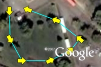 GPS track on Google Earth. |
Time Slider: If you have GPS tracks or other data that contains time information, you can view this information sequentially using the time slider in Google Earth. Excel To Kml looks for time information in columns labeled TimeWhen, TimeBegin, and TimeEnd.
+ نوشته شده در شنبه نهم اردیبهشت ۱۳۹۱ ساعت 22:3 توسط حمیدرضاحسن آبادی
|
 حمیدرضاحسن آبادی هستم